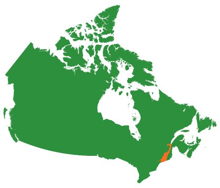
St. Lawrence Valley
![]()
![]()
St. Lawrence Valley
![]()
![]()
Federal ecozones: Mixedwood Plains
Area: 36,475 km2
Natural cover: 20,797
Per cent natural: 57%
Protected area: 5,752 km2
Per cent protected: 16%
Number of NCC projects (all): 194
Number of species of birds: 256
Number of species of trees: 82
Number of species of mammals: 78
Number of species of amphibians: 23
Estimated human population: 6,236,118
The St. Lawrence Valley includes the lowlands along the St. Lawrence, Ottawa and Saguenay rivers. This is a landscape dominated by these massive rivers, as well as forests and fertile agricultural lands. Mixedwood forests of sugar maple, yellow birch, eastern hemlock and eastern white pine are the dominant forest type in this region.
St. Lawrence Valley Landscape
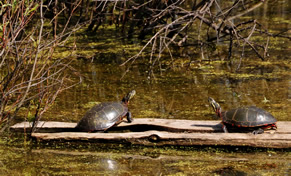
The lands and waters of the St. Lawrence Valley have a very high abundance and diversity of species and habitats. Although the region has been heavily impacted, there are still intact shoreline ecosystems and important habitats for rare species.
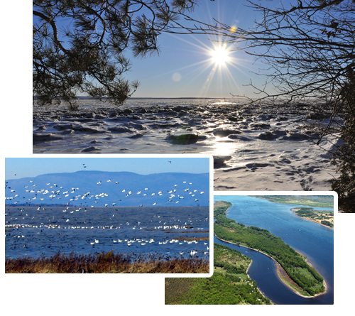
The estuary and coasts are very important for marine and shoreline species. In addition to marine mammals, seabirds and marine fishes migrate to the area to feed in the rich waters of the estuary.
The St. Lawrence Valley biodiversity hot spot includes habitat for several endemic species, such as copper redhorse and Victorin’s gentian.
It also includes the meeting place between the St. Lawrence River and the influence of the Atlantic Ocean, creating a large and biologically diverse estuary ecosystem, which includes habitat for blue whale, fin whale, minke whale and beluga whale. The salt marshes in the estuary provide habitat for many rare species, including butterflies and plants that are endemic to the area.
The St. Lawrence Valley is one the most densely populated areas of Canada, and is dominated by private lands. It is characterized by agricultural lands, and habitat loss and fragmentation is continuing.
Traditional settlement patterns of long, narrow strips along the river create unique challenges for conservation. Many wetlands have historically been converted for agriculture and development; the last remaining ones, including peat bogs, are still very vulnerable.
NCC has identified priority conservation sites in a number of natural areas, including:
In addition to habitat protection, management and restoration, NCC is also working with municipalities to share information about important biodiversity areas. Species at risk that are protected on NCC properties in this region include spiny softshell turtle, green dragon, channel darter and several birds.

Photo Credits (Top to bottom): Claude Duchaine, NCC, NCC, Claude Duchaine.
© 2023 Nature Conservancy of Canada (NCC) | TM Trademarks owned by the Nature Conservancy of Canada.
Charitable Reg. Number: 11924 6544 RR0001